Provision of urban local bodies (ULBs)/DSO to assign one or more sanitation workers to each request:
Sanitation workers will be made available via integration with the Garima database through API in the workflow.
Since the Garima ID may not be well known to the ULB/DSO, a search functionality is to be made available by entering a phone number.
Preview details of the selected sanitation worker for confirmation.
Capture sanitation worker details if a sanitation worker is not available in the Garima database.
Provide aggregated data around how many requests are served by date via unique Garima IDs by API to UMC.
No linking will be done between the Garima worker and the vendor in Sujog FSM.
Provide enumeration and benefits to sanitation workers.
Identify the percentage of services with evidence of safe practices.
Create UrcConfig.json and add GP data for all the ULBs for which the URC feature needs to be enabled.
Created two adaptors for Garima:
1. Create API
- The adapter calls the UMC API to create records and generate the unique garima ID.
2. Search API
- Get a response from the UMC API based on the search criteria.
Changes made in the FSM Update API
When we update the FSM application, we create a record of Garima in the DIGIT system simultaneously which uses the individual service to create an individual record in the DIGIT database.
Accordingly, one needs to set up the individual service for Garima.
Create a Garima folder in web\micro-ui-internals\packages\modules\fsm\src\pages\employee
Add the following code.
https://github.com/egovernments/digit-ui/blob/900f784b813f0e733ee0b9eae162759345248d42/web/micro-ui-internals/packages/modules/fsm/src/pages/employee/GarimaDetails/index.js#L1C1-L200C30
Add the required Garima custom components and register them.
Register the above custom page components:
Add the redirection URL for the "Add vehicle" action option:
Add the necessary Garima hooks call:
The following localisations need to be added:
/individual/v1/_search
UMC
api/egov/sanitation-worker/search
/api/v1/egov/sanitation-worker/capture
https://github.com/egovernments/digit-ui/blob/900f784b813f0e733ee0b9eae162759345248d42/web/micro-ui-internals/packages/modules/fsm/src/pageComponents/GarimaPersonalDetails.js#L1C1-L199C38
Feature
Service Name
PR
Added new component for URC
data/pg/FSM/CommonFieldsConfig.JSON
Create UrcConfig.json to enable URC feature
data/pg/angul/FSM/UrcConfig.json
Enabling overRide for tripAmount
data/pg/FSM/Config.json
Added GP data for specific ulb
Feature
Service Name
Changes
Garima
FSM
https://github.com/egovernments/DIGIT-Dev/commit/5f28f07e9a43597da22703964edb00f8f554c1fc https://github.com/egovernments/DIGIT-Dev/commit/7b325edf26f34aaad0b8a1aa09f132c47232424c https://github.com/egovernments/DIGIT-Dev/commit/0405a900dd8a12de03b60bb0f47ab1733ca03e66 https://github.com/egovernments/DIGIT-Dev/commit/5f44d9c3dc0b7515beb10b53ba4e6c06d0df2833 https://github.com/egovernments/DIGIT-Dev/commit/99f15a522f70f0a44a4335b9492cd4b7d589e0c1 https://github.com/egovernments/DIGIT-Dev/commit/4f16b9e9681ebca19e814ed2ec8cf256cb08946c
FSM
egovio/fsm:FSM1.3Impl-sujog-Odisha-handover-pqm-4f16b9e968-176
egovio/fsm-db:FSM1.3Impl-sujog-Odisha-handover-pqm-4f16b9e968-176
Individual
egovio/individual-db:sujog-individual-d13a5d35fb-199
egovio/individual:sujog-individual-d13a5d35fb-199
Digit-ui
egovio/digit-ui:FSM-Sujog-40157ab-325
FSM
/fsm/v1/_update
/fsm/v1/_searchGarimaWorker
/fsm/v1/_createGarimaWorker
Individual
/individual/v1/_create
data/pg/ulb-name/egov-location/boundary-data.json
[
  {
    "code": "ADD_DRIVER_MOBILE_NUMBER",
    "message": "Add driver's mobile number",
    "module": "rainmaker-fsm",
    "locale": "en_IN"
  },
  {
    "code": "ADD_HELPER",
    "message": "Add Helper",
    "module": "rainmaker-fsm",
    "locale": "en_IN"
  },
  {
    "code": "ADD_HELPER_MOBILE_NUMBER",
    "message": "Add helper's mobile number",
    "module": "rainmaker-fsm",
    "locale": "en_IN"
  },
  {
    "code": "ASSIGN_DRIVER",
    "message": "Assign driver",
    "module": "rainmaker-fsm",
    "locale": "en_IN"
  },
  {
    "code": "ASSIGN_HELPER",
    "message": "Assign helper",
    "module": "rainmaker-fsm",
    "locale": "en_IN"
  },
  {
    "code": "ASSIGN_SANIATION_WORKER",
    "message": "Assign sanitation worker",
    "module": "rainmaker-fsm",
    "locale": "en_IN"
  },
  {
    "code": "ES_FSM_ADD_DRIVER_SUCCESS",
    "message": "Driver Added Successfully",
    "module": "rainmaker-fsm",
    "locale": "en_IN"
  },
  {
    "code": "ES_TITLE_DRIVER_DETAILS",
    "message": "Driver Details",
    "module": "rainmaker-fsm",
    "locale": "en_IN"
  },
  {
    "code": "GARIMA_DRIVER",
    "message": "Driver",
    "module": "rainmaker-fsm",
    "locale": "en_IN"
  },
  {
    "code": "FSM_HELPER_LABEL",
    "message": "Helper",
    "module": "rainmaker-fsm",
    "locale": "en_IN"
  },
  {
    "code": "GARIMA_HELPER",
    "message": "Helper",
    "module": "rainmaker-fsm",
    "locale": "en_IN"
  }
]The urban-rural convergence is an initiative that aims to ensure access to sanitation services to all gram panchayats (GPs) via urban local bodies (ULBs) located closest to them.
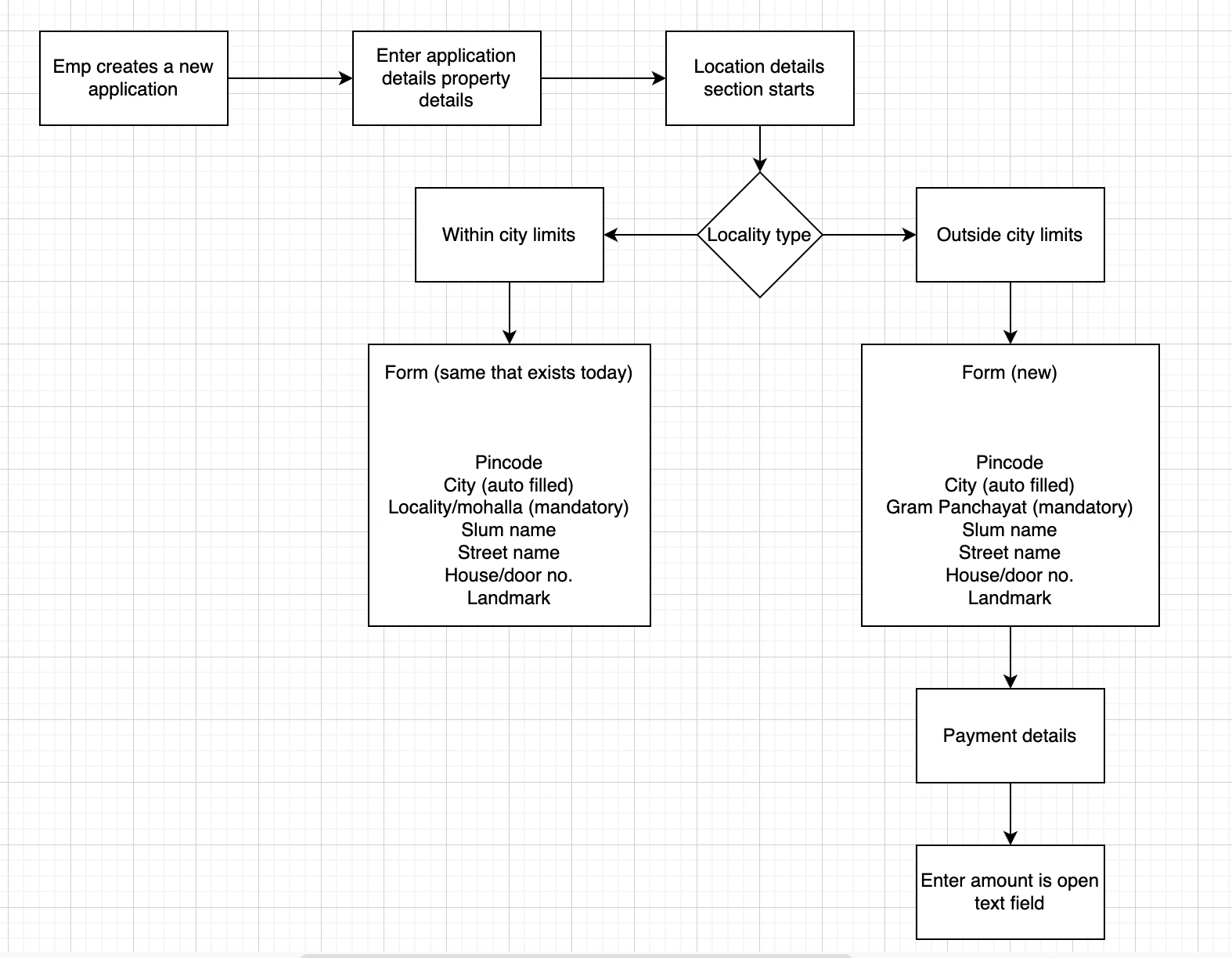
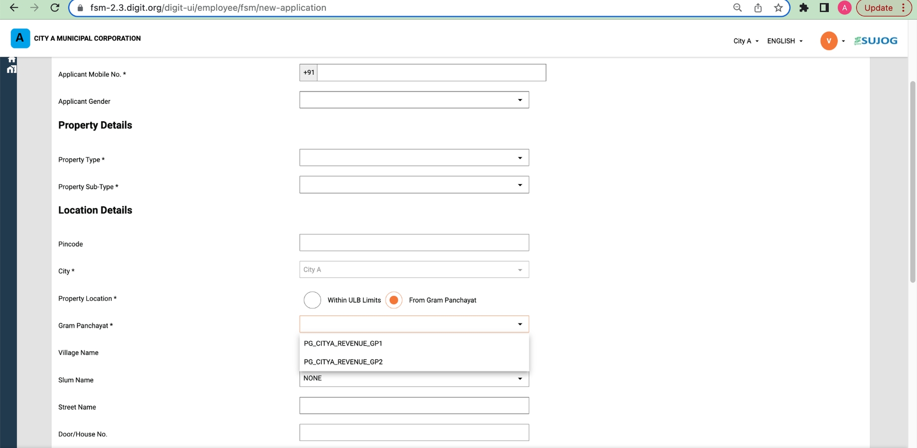
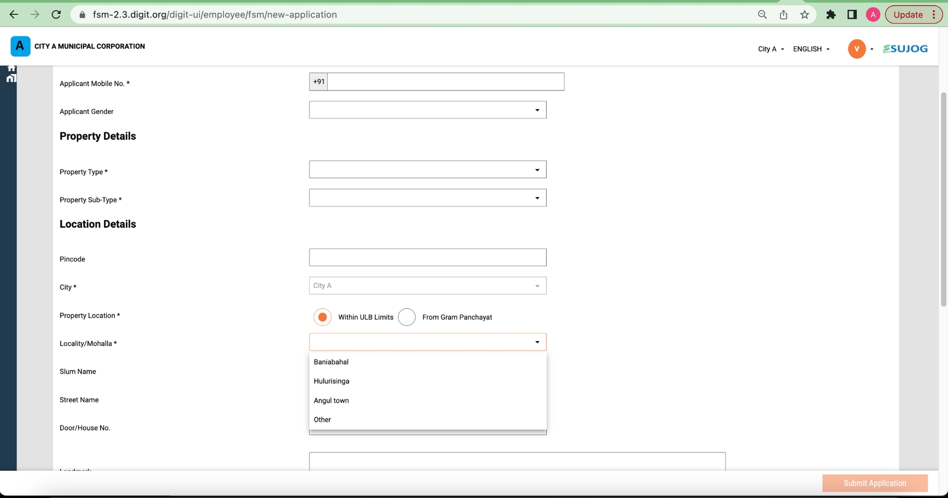
A ULB employee creates applications to cater to the sanitation needs of local communities in urban areas. In the same way, they should also cater to the same sanitation needs of rural bodies near that urban region.
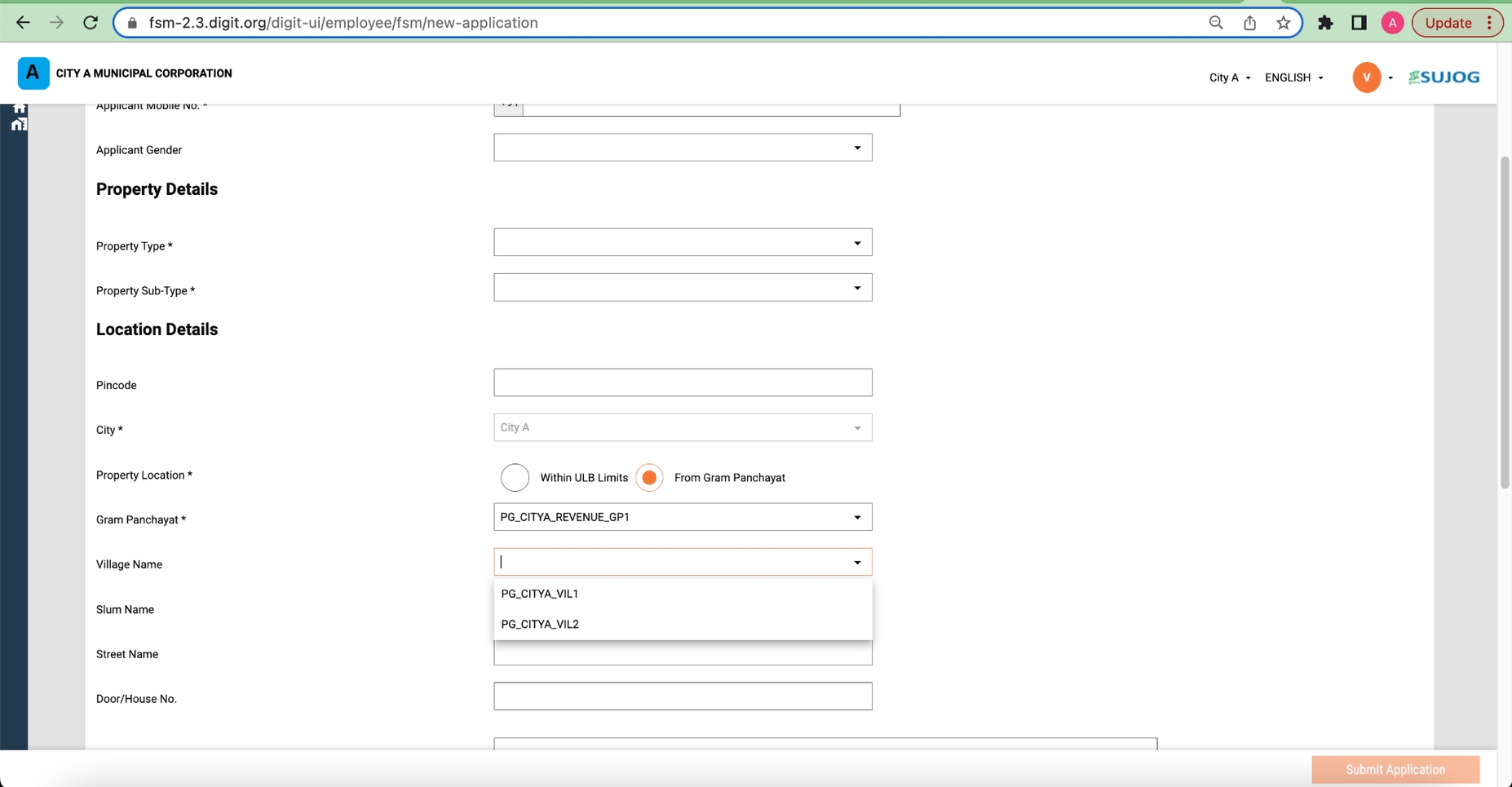
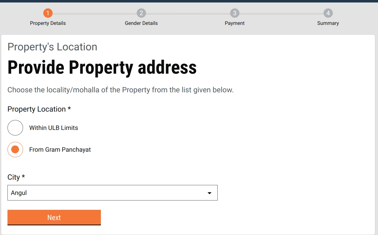
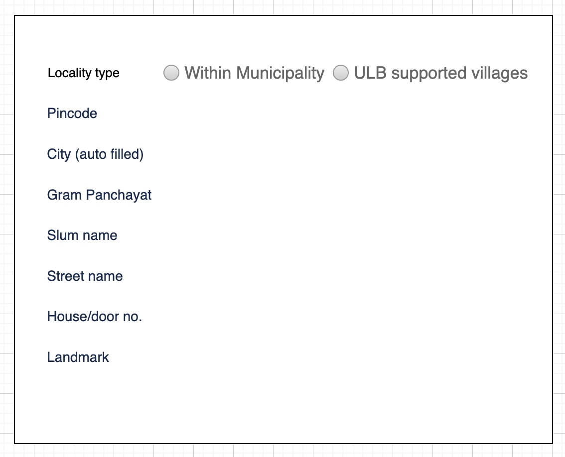
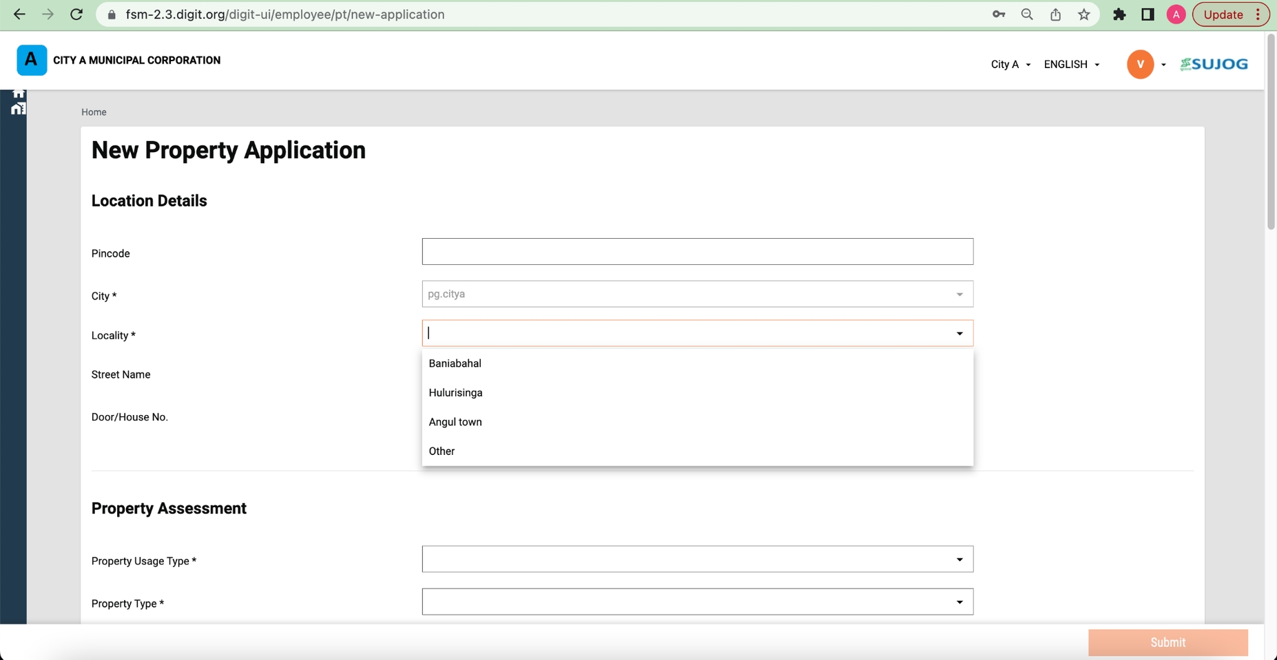
They need a provision in a system while creating a new application to either choose local municipalities or urban-supported villages.
Based on their choice they would be able to select either a locality/mohalla or a GP area from the respective master data drop-down list.
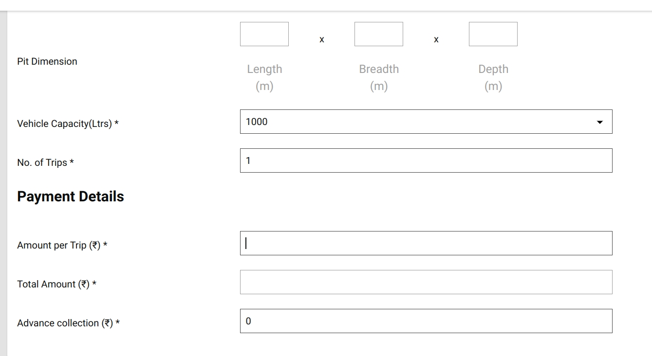
The caveat here is that if a ULB employee chooses GP, then the trip amount field should be editable where he/she can fill in any logical amount based on the offline calculation instead of the auto-calculated amount already there in an application in the case of urban bodies.
ULB employees or DSO operators should also be able to edit the number of trips. The final amount should be multiple of the initial amount entered into an application with the number of trips.
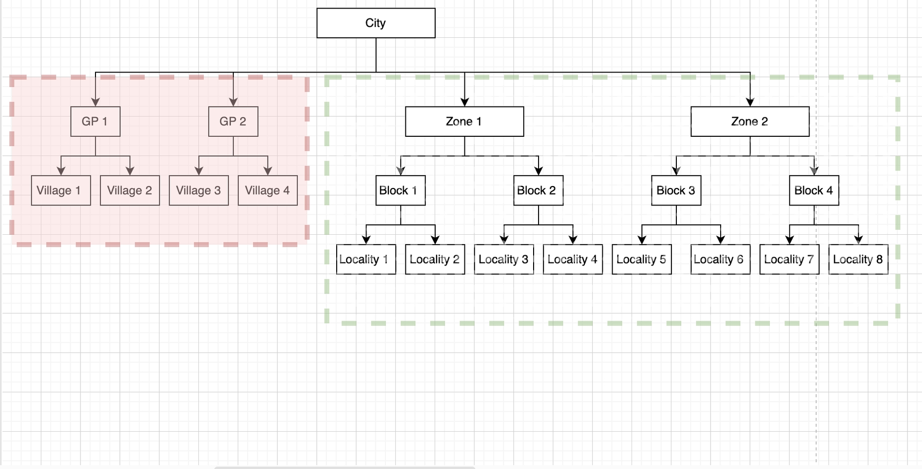
Update the MDMS data: boundary-data.json
- Add a new children hierarchy for GP under city which will be parallel to locality. A sample MDMS is attached below:
By default, the 'Urban' option will be pre-selected in the radio button in the above wireframe and the drop-down will have the locality/mohalla master data. If an employee selects “ULB supported village”, then the locality/mohalla drop-down will be replaced by GPs and village drop-down data on the fly.
boundary-data.json
UrcConfig.json
To enable URC feature in the UI:
We are keeping the locality hierarchy under the city as it is [No change there]. And the ‘location api’ with boundaryType as 'locality' will be used the same way it's being called currently to get the localities. Below are the API details: boundaryType=Locality&tenantId=pb.amritsar Response:
To get a list of gram panchayats and corresponding villages, pass the boundaryType as 'GP'. Below are the API details: boundaryType=GP&tenantId=pb.amritsar
To analyse the impact, we deployed a different module (property tax) which points to the same boundary-data mdms.
Expectation:
For FSM Module: Non-URC flow: The locality drop-down should show all the localities as it is (there should be no impact). URC flow: The gram panchayat and village drop-down should show as per the new GP and village added to the MDMS.
For Property Tax Module: The locality drop-down should show all the localities as it is (there should be no impact).
Property Tax Screen:
The locality dropdown in property tax displays the values from the existing location hierarchy itself (there is no impact).
SUJOG FSM (NON-URC)
In FSM, for non-URC, the locality drop-down shows the values from the existing hierarchy itself (there is no impact)..
SUJOG FSM (URC)
GP drop-down In the case of FSM (URC), the gram panchayat and village drop-downs are showing values from the new hierarchy we have configured in the existing MDMS.
Village Dropdown
Pricing
In FSTP, there are two scenarios -
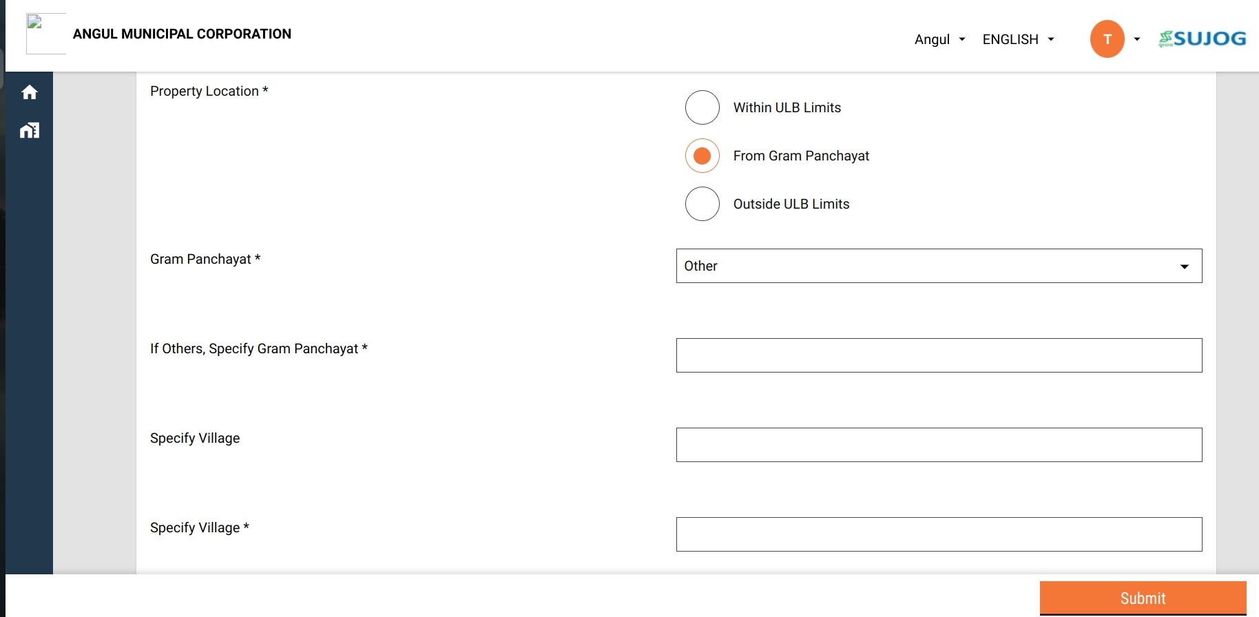
Selects a gram panchayat from drop-down but the village is not in the list. In this case, select 'other' in the village and a free text field appears.
Select 'other' in the GP list. In this case, 2 free text fields appear - one for GP and one for village.
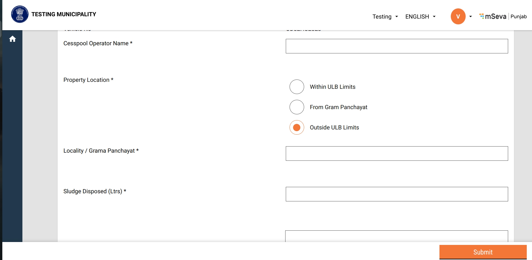
If the locality or GP is located outside the city, then select “Outside ULB Limits” and provide the locality/gram panchayat name in the text field.
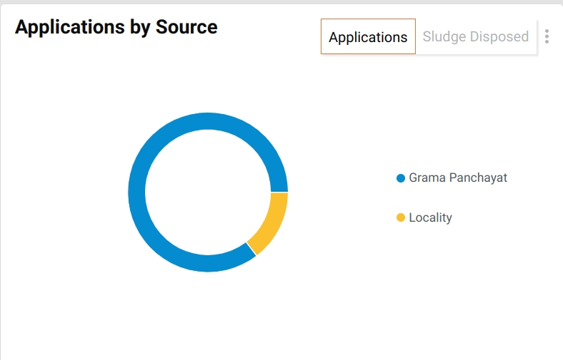
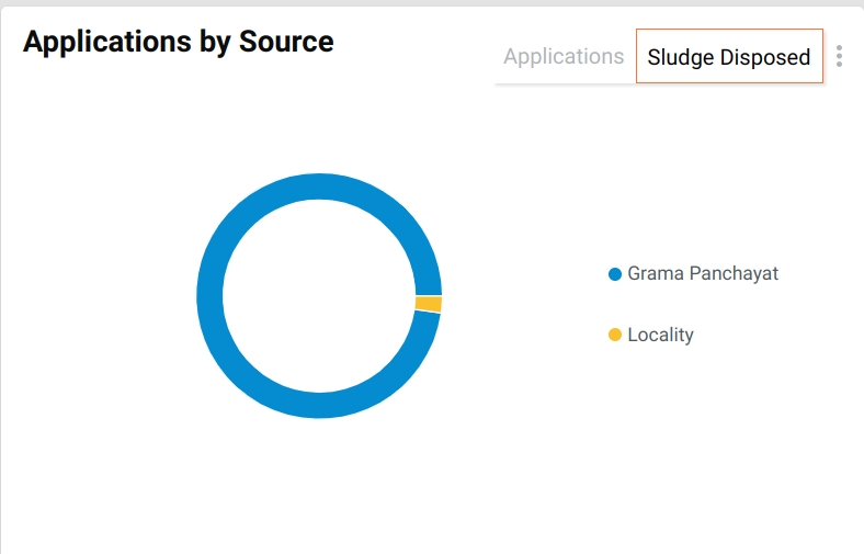
In the dashboard, add the following chart:
Add pie chart: Applications by source
Pie chart value: Ratio of applications from GP: Ratio of requests from urban areas.
Add toggle for applications and sludge.
Pie chart value: Ratio of sludge disposed from GP: Ratio of sludge from urban areas.
- In the case of localities, one needs to pass boundaryType as “Locality”.
https://dev.digit.org/egov-location/location/v11/boundarys/_search?hierarchyTypeCode=REVENUE&boundaryType=Locality&tenantId=pb.amritsar
- In the case of GP/villages, one needs to pass the boundaryType as “GP”.
https://dev.digit.org/egov-location/location/v11/boundarys/_search?hierarchyTypeCode=REVENUE&boundaryType=GP&tenantId=pb.amritsar
Introduction of a new string column (boundary_type) in the FSM_APPLICATION table to capture (locality or GP) to determine if the application created is for rural or not so that in the near future it will be helpful for the analytics and statistics in dashboards.
- The default value for this column will be locality to support backward compatibility
Adding a vehicle log would also have the option to select urban (default option) or rural. If rural gets selected the text name of an element would be replaced from 'locality' to “Gram Panchayat” for a text field.
Introduction of a new column of string type (boundary_type) in the vehicle_trip table to capture if the vehicle log is created for the GP or not.
- The default value for this column will be Locality to support backward compatibility.
To capture (locality or GP) if the vehicle log is created for GP or not.
Pricing per trip will be entered by “ULB employees” for each request.
ULB employees will have a free text entry field to enter the price for a request.
Tooltip: Show total applications and total sludge (See design). Tooltip value to be responsive to toggle between unit, lakh, and crore.
The chart should filter based on the period, district, ULB (dashboard filters).
The chart should have export, share, and download options.
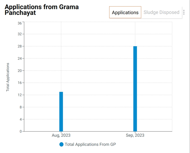
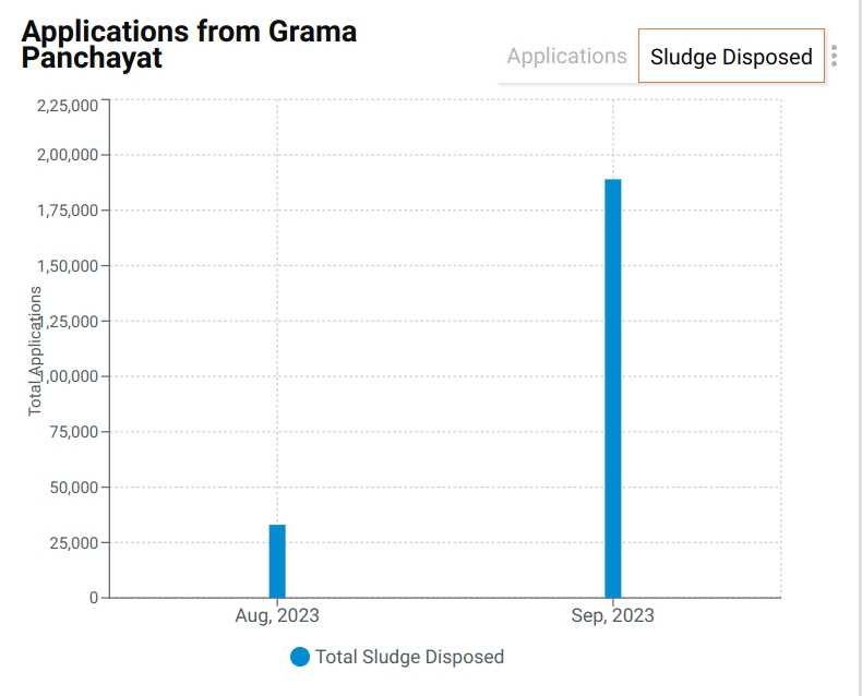
Add bar chart: Number of applications per month from the GP.
Bar chat value: The total number of applications from the GP.
Add toggle for applications and sludge disposed.
Tooltip: Show the total applications and total sludge (See design). Tooltip value to be responsive to toggle between unit, lakh, and crore.
The chart should filter based on the period, district, ULB (dashboard filters).
The chart should have export, share, and download options.
Table Name
Column Name
Comments
eg_fsm_application
boundarytype
To capture (locality or GP) to determine if the application created is for rural or not based on the radio button selection.
eg_fsm_address
additionaldetails.gramPanchayat
To store the selected GP while creating an application.
eg_fsm_address
additionaldetails.village
To store the selected village while creating an application.
eg_vehicle_trip
boundarytype
{
    "tenantId": "pb.amritsar",
    "moduleName": "egov-location",
    "TenantBoundary": [{
        "hierarchyType": {
          "code": "REVENUE",
          "name": "REVENUE"
        },
        "boundary": {
          "id": 1,
          "boundaryNum": 1,
          "name": "Angul",
          "localname": "Angul",
          "longitude": null,
          "latitude": null,
          "label": "City",
          "code": "od.angul",
          "children": [{
              "id": "2",
              "boundaryNum": 1,
              "name": "Baniabahal",
              "localname": "Baniabahal",
              "longitude": null,
              "latitude": null,
              "label": "Locality",
              "code": "VIL1"
            },
            {
              "id": "3",
              "boundaryNum": 1,
              "name": "Hulurisinga",
              "localname": "Hulurisinga",
              "longitude": null,
              "latitude": null,
              "label": "Locality",
              "code": "VIL2"
            },
            {
              "id": "4",
              "boundaryNum": 1,
              "name": "Angul town",
              "localname": "Angul town",
              "longitude": null,
              "latitude": null,
              "label": "Locality",
              "code": "VIL3"
            },
            {
              "id": "5",
              "boundaryNum": 1,
              "name": "Other",
              "localname": "Other",
              "longitude": null,
              "latitude": null,
              "label": "Locality",
              "code": "VIL4"
            },
            {
              "id": 6,
              "boundaryNum": 1,
              "name": "GP 1",
              "localname": "GP1",
              "longitude": null,
              "latitude": null,
              "label": "GP",
              "code": "GP1",
              "children": [{
                  "id": 11,
                  "boundaryNum": 1,
                  "name": "Village 1",
                  "localname": "Village local 1",
                  "longitude": 74.871552,
                  "latitude": 31.63089,
                  "label": "Village",
                  "code": "SUN04",
                  "pincode": [143001],
                  "area": "V-Area1",
                  "children": []
                },
                {
                  "id": 12,
                  "boundaryNum": 1,
                  "name": "Village 2",
                  "localname": "Village local 2",
                  "longitude": null,
                  "latitude": null,
                  "label": "Village",
                  "code": "SUN11",
                  "pincode": [143001],
                  "area": "V-Area1",
                  "children": []
                }
              ]
            },
            {
              "id": 8,
              "boundaryNum": 1,
              "name": "GP 2",
              "localname": "GP2",
              "longitude": null,
              "latitude": null,
              "label": "GP",
              "code": "GP2",
              "children": [{
                  "id": 13,
                  "boundaryNum": 1,
                  "name": "Village 3",
                  "localname": "Village local 3",
                  "longitude": 74.871552,
                  "latitude": 31.63089,
                  "label": "Village",
                  "code": "SUN04",
                  "pincode": [143001],
                  "area": "V-Area1",
                  "children": []
                },
                {
                  "id": 14,
                  "boundaryNum": 1,
                  "name": "Village 4",
                  "localname": "Village local 4",
                  "longitude": null,
                  "latitude": null,
                  "label": "Village",
                  "code": "SUN11",
                  "pincode": [143001],
                  "area": "V-Area1",
                  "children": []
                }
              ]
            }
          ]
        }
      },
      {
        "hierarchyType": {
          "code": "ADMIN",
          "name": "ADMIN"
        },
        "boundary": {
          "id": 1,
          "boundaryNum": 1,
          "name": "Angul",
          "localname": "Angul",
          "longitude": null,
          "latitude": null,
          "label": "City",
          "code": "od.angul",
          "children": [{
              "id": "2",
              "boundaryNum": 1,
              "name": "Baniabahal",
              "localname": "Baniabahal",
              "longitude": null,
              "latitude": null,
              "label": "Locality",
              "code": "VIL1"
            },
            {
              "id": "3",
              "boundaryNum": 1,
              "name": "Hulurisinga",
              "localname": "Hulurisinga",
              "longitude": null,
              "latitude": null,
              "label": "Locality",
              "code": "VIL2"
            },
            {
              "id": "4",
              "boundaryNum": 1,
              "name": "Angul town",
              "localname": "Angul town",
              "longitude": null,
              "latitude": null,
              "label": "Locality",
              "code": "VIL3"
            }
          ]
        }
      }
    ]
}{
"tenantId": "pg.angul",
"moduleName": "FSM",
"urcConfig": [
{
"URCEnable": true,
"villageHierarchyAvailable": true
}
]
}{
"ResponseInfo": {
"apiId": "org.egov.boundary",
"ver": null,
"ts": "",
"resMsgId": "uief87324",
"msgId": null,
"status": "200 OK"
},
"TenantBoundary": [
{
"hierarchyType": {
"id": null,
"name": "REVENUE",
"code": "REVENUE",
"localName": null,
"tenantId": null,
"createdBy": null,
"createdDate": null,
"lastModifiedBy": null,
"lastModifiedDate": null,
"version": 0,
"new": false
},
"boundary": [
{
"code": "VIL1",
"name": "Baniabahal",
"label": "Locality",
"latitude": null,
"longitude": null,
"area": null,
"pincode": null,
"boundaryNum": 1,
"children": []
},
{
"code": "VIL2",
"name": "Hulurisinga",
"label": "Locality",
"latitude": null,
"longitude": null,
"area": null,
"pincode": null,
"boundaryNum": 1,
"children": []
},
{
"code": "VIL3",
"name": "Angul town",
"label": "Locality",
"latitude": null,
"longitude": null,
"area": null,
"pincode": null,
"boundaryNum": 1,
"children": []
},
{
"code": "VIL4",
"name": "Other",
"label": "Locality",
"latitude": null,
"longitude": null,
"area": null,
"pincode": null,
"boundaryNum": 1,
"children": []
}
],
"tenantId": "pb.amritsar"
}
]
}{
"ResponseInfo": {
"apiId": "org.egov.boundary",
"ver": null,
"ts": "",
"resMsgId": "uief87324",
"msgId": null,
"status": "200 OK"
},
"TenantBoundary": [
{
"hierarchyType": {
"id": null,
"name": "REVENUE",
"code": "REVENUE",
"localName": null,
"tenantId": null,
"createdBy": null,
"createdDate": null,
"lastModifiedBy": null,
"lastModifiedDate": null,
"version": 0,
"new": false
},
"boundary": [
{
"code": "GP1",
"name": "GP 1",
"label": "GP",
"latitude": null,
"longitude": null,
"area": null,
"pincode": null,
"boundaryNum": 1,
"children": [
{
"code": "SUN04",
"name": "Village 1",
"label": "Village",
"latitude": "31.63089",
"longitude": "74.871552",
"area": "V-Area1",
"pincode": [
143001
],
"boundaryNum": 1,
"children": []
},
{
"code": "SUN11",
"name": "Village 2",
"label": "Village",
"latitude": null,
"longitude": null,
"area": "V-Area1",
"pincode": [
143001
],
"boundaryNum": 1,
"children": []
}
]
},
{
"code": "GP2",
"name": "GP 2",
"label": "GP",
"latitude": null,
"longitude": null,
"area": null,
"pincode": null,
"boundaryNum": 1,
"children": [
{
"code": "SUN04",
"name": "Village 3",
"label": "Village",
"latitude": "31.63089",
"longitude": "74.871552",
"area": "V-Area1",
"pincode": [
143001
],
"boundaryNum": 1,
"children": []
},
{
"code": "SUN11",
"name": "Village 4",
"label": "Village",
"latitude": null,
"longitude": null,
"area": "V-Area1",
"pincode": [
143001
],
"boundaryNum": 1,
"children": []
}
]
}
],
"tenantId": "pb.amritsar"
}
]
}