> For the complete documentation index, see [llms.txt](https://docs.digit.org/llms.txt). Markdown versions of documentation pages are available by appending `.md` to page URLs; this page is available as [Markdown](https://docs.digit.org/sanitation/community/community-project-vehicle-tracking/architecture.md).
# Architecture
To ensure proper disposal of waste, the Swachh Bharat Mission has approved the building of deep row entrenchments for the disposal of sludge for up-to three years. With this mandate, there are approximately 10k+ deep row entrenchments that now exist, and are usually unmanned. To confirm disposal to these legal unmanned dumping sites, there is a need for automated verification of disposal at these sites.
India’s FSM ecosystem is made of highly interdependent parts, across the value chain of generation, containment, transport, treatment, and disposal/reuse. This means that there are different actors at each stage of the value chain whose behaviours and business models affect how well the next stage functions, creating a complex mesh of constraints that affect the effective functioning of the sanitation service delivery.
While the linear value chain gives a lucid frame to understand the ideal flow of faecal sludge, there are various points of friction between stakeholders that currently undermine the effectiveness of the sanitation value chain. Illegal dumping remains a challenge in regard to the waste value chain.
We want to improve the verifiability of the transport information on faecal sludge through the implementation of vehicle tracking to drive the following benefits:
1. Improved verification: The service enhances the verification process of the faecal sludge disposal. By accurately tracking the movement of vehicles carrying the sludge, it ensures that the sludge reaches its designated disposal site, providing transparency and accountability in the disposal process.
2. Removal of manual intervention to confirm disposal: The implementation of the vehicle tracking service removes the need for manual intervention to confirm the disposal of faecal sludge. Traditionally, manual methods involve physical confirmation by the treatment plant operator.
3. Identification of Illegal dumping: By closely monitoring the transportation of faecal sludge from the point of containment to disposal, the vehicle tracking service helps in minimising disposal in illegal sites. It facilitates identifying potential inefficiencies, route deviations, or incidents, allowing for prompt corrective actions.
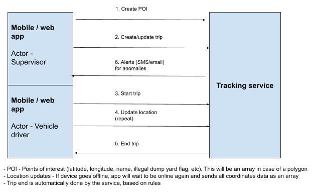
The vehicle tracking service within DIGIT aims to capture real-time spatial data by tracking vehicles from their starting coordinates (longitude and latitude) to their destination point. This service helps in enhancing the credibility of service delivery by providing a reliable means to track and verify the transportation process. The vehicle tracking service can be seamlessly integrated with various service delivery operations, offering the flexibility to configure it for different purposes.
Tracking Process
---
# Agent Instructions
This documentation is published with GitBook. GitBook is the documentation platform designed so that both humans and AI agents can read, navigate, and reason over technical content effectively. Learn more at gitbook.com.
## Querying This Documentation
If you need additional information that is not directly available in this page, you can query the documentation dynamically by asking a question.
Perform an HTTP GET request on the current page URL with the `ask` query parameter, and the optional `goal` query parameter:
```
GET https://docs.digit.org/sanitation/community/community-project-vehicle-tracking/architecture.md?ask=&goal=
```
`ask` is the immediate question: it should be specific, self-contained, and written in natural language.
`goal` is optional and describes the broader end goal you are ultimately trying to accomplish on behalf of the user. GitBook uses it to tailor the answer towards what is most useful for that goal.
The response will contain a direct answer to the question and relevant excerpts and sources from the documentation.
Use this mechanism when the answer is not explicitly present in the current page, you need clarification or additional context, or you want to retrieve related documentation sections.